


Gr36 Mareuil Rochebeaucourt

taguette
User
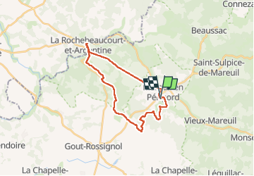

Length
24 km

Max alt
191 m

Uphill gradient
327 m
Km-Effort
29 km

Min alt
89 m

Downhill gradient
331 m
Boucle
Yes
Creation date :
2025-06-09 06:20:08.292
Updated on :
2025-06-09 11:47:36.818
5h26
Difficulty : Very difficult

FREE GPS app for hiking
 SityTrail
IGN / Geographical institutes
SityTrail Plus
The world is yours!
About
Trail Walking of 24 km to be discovered at New Aquitaine, Dordogne, Mareuil en Périgord. This trail is proposed by taguette.
Positioning
Country:
France
Region :
New Aquitaine
Department/Province :
Dordogne
Municipality :
Mareuil en Périgord
Location:
Mareuil
Start:(Dec)
Start:(UTM)
300634 ; 5035775 (31T) N.
Comments